(April 1, 2025) Minneapolis, Minn. — Governor Tim Walz and Mayor Jacob Frey announced the designation of Minneapolis as Minnesota’s capital city this morning. A vibrant redevelopment plan has also been announced for the former State Capitol building in St. Paul.
Facing backlash from an abruptly announced return to work policy last week, Gov. Walz shared his hope that this would allay workers’ concerns at a press conference this morning. “Look, I get it, a commute to the east metro isn’t easy. We need our state employees back in the office — but we’re bringing that office to the central city of our region, Minneapolis,” Walz stated this morning.
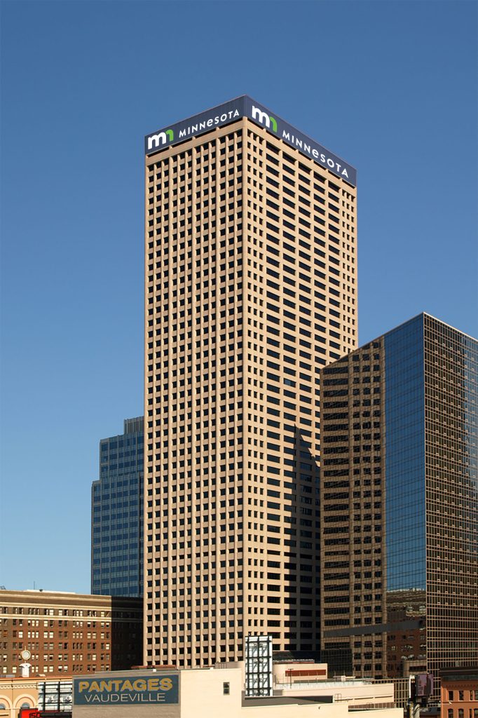
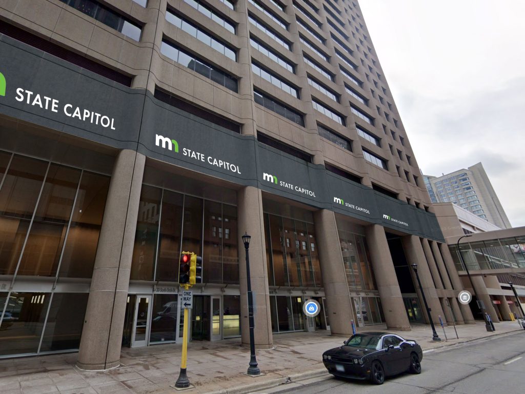
City Center (33 South Sixth) as new Capitol
The new State Capitol will be located at 33 S 6th Street, in one of Minneapolis’s most beloved and architecturally admired skyscrapers — City Center.
The attractive “mn” branding will make a landmark of the Minneapolis skyline.
Originally built as the International Multifoods Tower, City Center has long been noted for its sense of liveliness and civic inspiration. The tower presents far better branding opportunities than the outdated Cass Gilbert-designed facility in St. Paul.
“When I think of the distinctive style of our new unified Minnesota brand, I just think of City Center!” said Walz excitedly admiring the state’s lower-case “mn” logo.
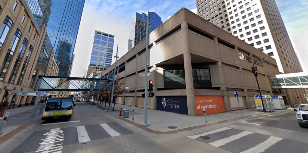
While Minneapolis Mayor Jacob Frey was excited to welcome the seat of government, he acknowledged that serious help was needed to facilitate the connection between the new State Capitol and Nicollet Mall.
Referencing the image above, Frey explained in an interview with Streets.mn: “Look, I see what you see: plain concrete panels, no storefronts, covered-over windows. I think we can all agree that something needs to be done, which is why I am committing to addressing the worst part of this image: the bus currently running on the Mall will be eliminated.”
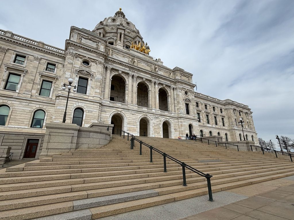
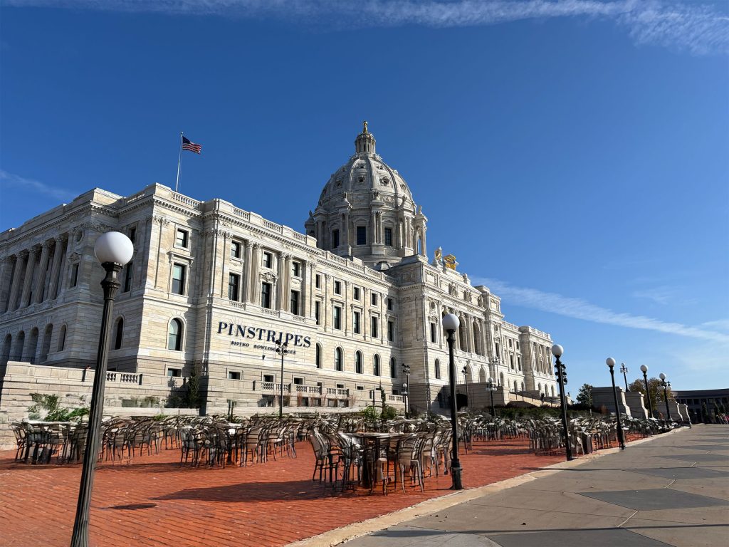
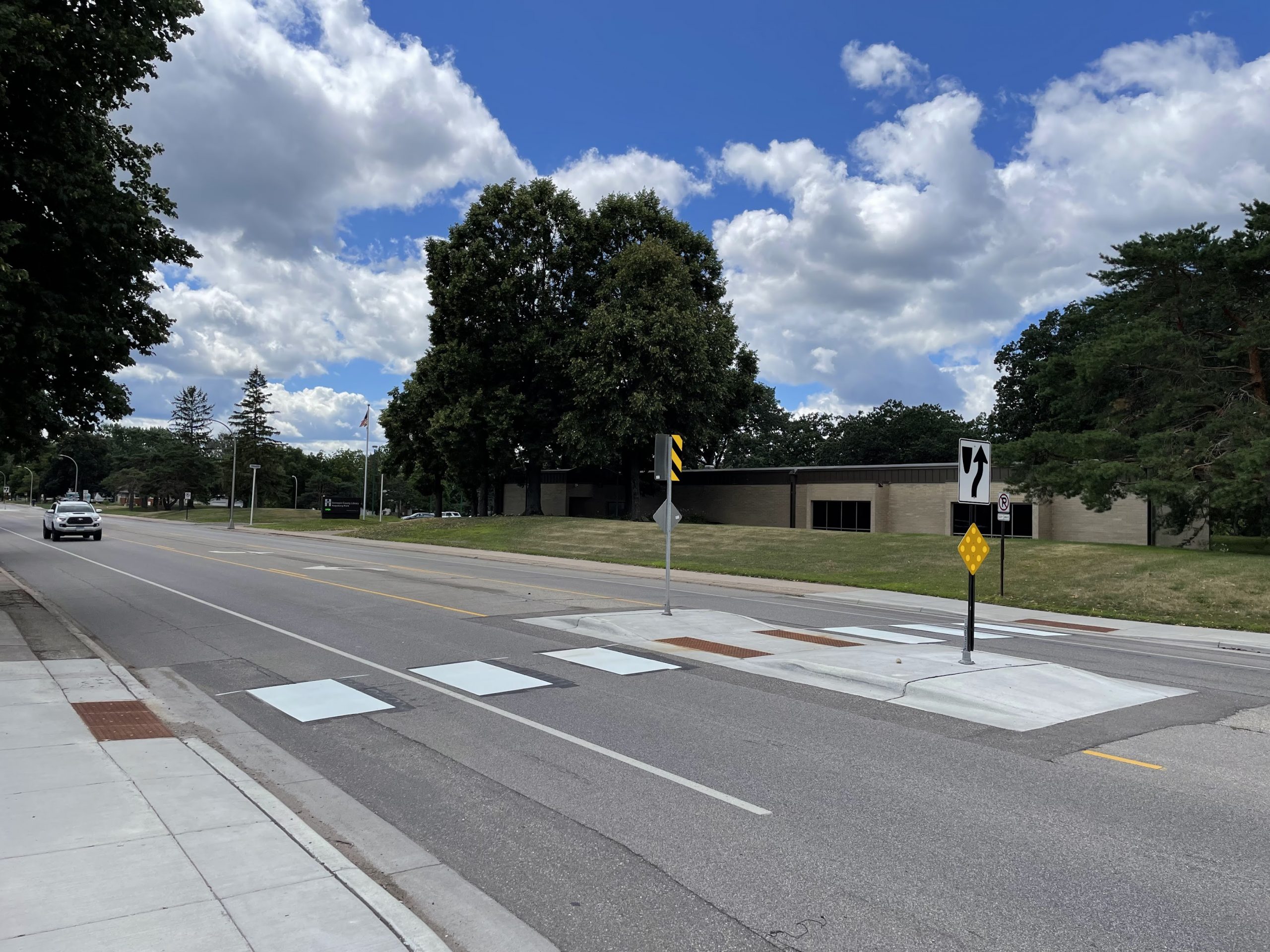
The outdated and inaccessible steps of the former State Capitol.
The attractive, inspiring civic frontage of the new State Capitol.
The new State Capitol location was praised across the political spectrum.
“Removing 33 South Sixth’s $5 million a year from the tax rolls will help reduce the nefarious role capitalism plays in our government. It’s just one small step, but we are committed to ensuring no private profit will be used to fund our government,” the Twin Cities DSA central committee said in a statement.
Although Republican leaders preferred the Andover alternative for relocation, they have embraced the opportunity to divest from costly civic landmarks and promote private profit. “It’s no Andover, but the move to Minneapolis is meaningful progress for our state,” said MN House Speaker Lisa Demuth (R – Duluth). “Our caucus is particularly excited about the private equity buyout of the dated, costly former State Capitol.”
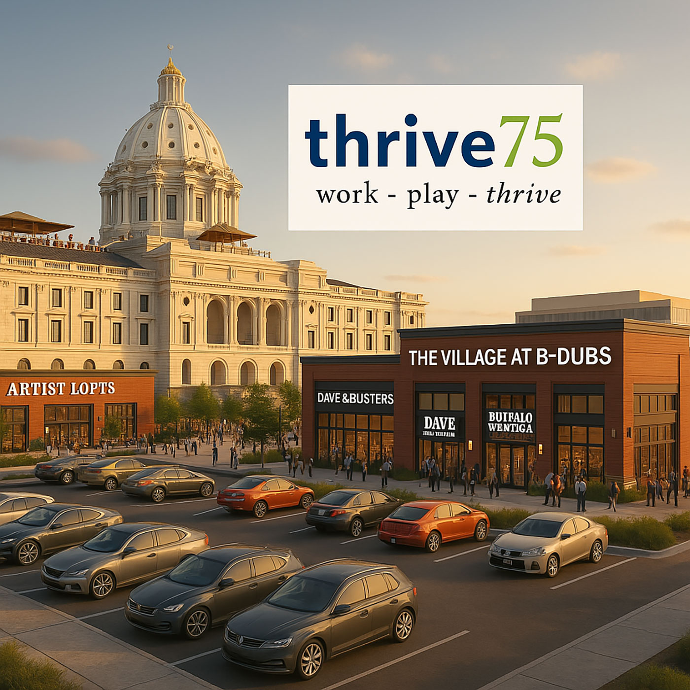
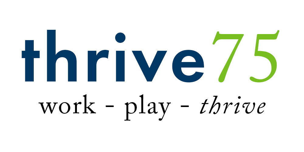
Former State Capitol as “Work Play Thrive” Redevelopment
While impractical as a seat of government, the outdated former State Capitol is expected to be transformed into a vibrant, “Work Play Thrive” redevelopment called thrive75, a reference to its street address at 75 Martin Luther King Jr Blvd.
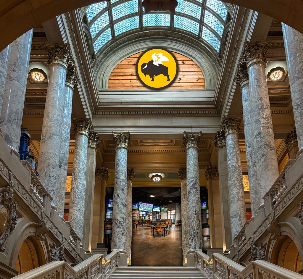
Key anchors Pinstripes, Dave & Buster’s, and Buffalo Wild Wings were announced Tuesday.
Pinstripes Bocce and Bowling will occupy much of the west wing of the former capitol, activating the capitol grounds and providing a lively destination to the region.
The second floor will be largely occupied by a flagship Buffalo Wild Wings.
Finally, the third floor is scheduled to reopen as a Dave & Buster’s, opening early 2026. The Quadriga Cornhole Toss is expected to be a popular feature.
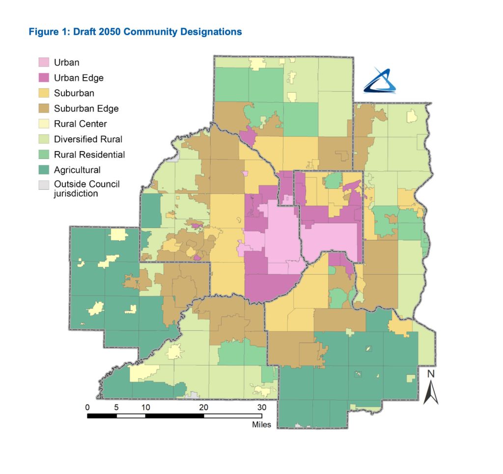
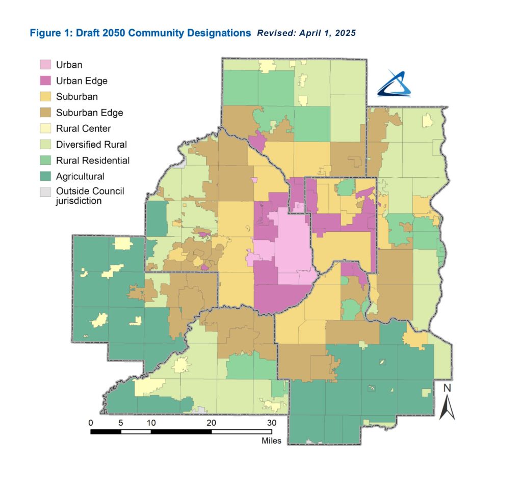
St. Paul Redesignated as Suburban Community
At press time, Metropolitan Council officials were working to redesignate the City of St. Paul as a suburban community in their forthcoming Imagine 2050 plan.
The incorrect map showing St. Paul as urban.
Revised draft map announced April 1, redesignating St. Paul as suburban.
Suburban activists with the Save our Street and Neighbors for a Livable St. Paul coalitions expressed excitement for the new classification, including the opportunity to block additional bike lanes and apartments.
St. Paul, Minn. — The St. Paul Port Authority (SPPA), the city’s redevelopment agency, announced an exciting initiative to bring much-needed investment and redevelopment to the struggling Ayd Mill Road corridor. The plan is called the Ayd Mill Stroad Opportunity Corridor.
“Ayd Mill has long suffered an identity crisis,” acknowledged St. Paul Port Authority spokesman Jeffrey Industrielle. “Is it a road to connect to 35E? Is it a street or parkway for the neighborhood? Our answer: It’s neither. It’s a stroad of opportunity.”
Ayd Mill History
Ayd Mill Road is a short connector from Interstate 35E to Selby Avenue. Although it was originally envisioned as connecting to I-94 slightly farther north, the road has long ended at its current terminus, with only the south end connecting to the freeway system.
The road was originally called “Short Line Road,” a storied history reflected in SPPA’s slogan for the project, “The Short Line to Prosperity.”
Ayd Mill Stroad prior to proposed Opportunity Corridor improvements (photo: Bill Lindeke)
“The Great Northern Business Center is one of our greatest successes,” said spokesman Industrielle. “Walk score of 71, a 10-minute walk to the Green Line? I can’t think of a better place to put semi-trucks and a low-density warehouse.”
The Great Northern Business Center (pictured) is a past project of St. Paul Port Authority, carefully designed to complement its urban, prewar neighborhood context. (Image: Google Street View)SPPA took the Arlington Jackson redevelopment site from a disused plot of land to a vibrant work-play-stay development (pictured). The ornamental railing is a subtle homage to St. Paul’s rich history. (Image: Google Street View)
New Vision Shows Strategic Public-Private Partnership
Although the St. Paul Port Authority often begins land work prior to new businesses being identified, the Ayd Mill Stroad Opportunity Corridor is being announced with private partners at the ready.
Respected national businesses such as Walmart, Amazon.com and Kwik Trip are already committed to invest in St. Paul.
Walmart to Revitalize Grand (Bargains) Avenue
The first project is unusual for the St. Paul Port Authority: While typically partnering to build warehouses, SPPA will instead be building a discount shopping warehouse, in the form of a Walmart Super Center. The exciting new development will anchor the corner of Grand Avenue and Ayd Mill Stroad.
To recognize the investment in the community, Grand Avenue will be renamed Grand Bargains Avenue.
“We’ve heard a lot about Grand Avenue businesses struggling in recent years, but if we know there’s one thing that fixes a flagging main street, it’s a new Walmart,” beamed Industrielle.
“The name Grand Bargains Avenue was chosen after an extensive focus group of guys from Arden Hills and Eagan who we believe will be optimally positioned to shop at this new Walmart.”
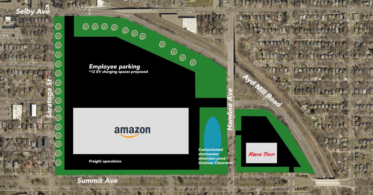
Amazon Fulfillment Center to Provide High-Quality, Living-Wage Jobs
The second project will improve approximately 350 homes into an Amazon fulfillment center, with ample green space and quasi-public stormwater features. Kwik Trip will be occupying the eastern outlot, providing convenience to the regional motorist and up to two-dozen minimum wage jobs. Selby Avenue will be renamed Amazon Parkway.
Local Summit Avenue advocacy group Save our Street (SOS) was quick to embrace the proposal, telling Streets.mn in a statement, “By providing ample parking, the proposed Amazon–Kwik Trip campus will preserve the most important historical features of Summit Avenue: widely available on-street parking lanes. As long as there’s no bike trail, the integrity of this iconic street will be preserved for future generations.”
At press time, the Minnesota Department of Transportation announced that it was seeking funding to study conversion of the Hamline Avenue–I-94 interchange into a Diverging Diamond to help support this critical economic development initiative.
Editor’s note: April Fools’! The longstanding tradition at Streets.mn continues.
Have you ever had a friend return from a vacation and gush about how great it was to walk in the place they’d visited? “You can walk everywhere! To a café, to the store. It was amazing!” Immediately after saying that, your friend hops in their car and drives across the parking lot to the Starbucks to which they could easily have walked.
Why does walking feel so intuitive when we’re in a city built before cars, yet as soon as we return home, walking feels like an unpleasant chore that immediately drives us into a car?
A lot contributes to this dilemma, like the density of the city, or relative cheapness and convenience of driving. But there’s a bigger factor here: We don’t design the pedestrian experience for dignity.
This is a national problem, but certainly one we can see throughout our own Twin Cities metro: Even where pedestrian facilities are built, brand-new, ADA-compliant and everything else — using them feels like a chore, or even stressful and unpleasant.
Dignity is a really important concept in active transportation, but one that we often miss in the conversation about making streets better for walking and biking. I’ve been delighted to see the term appear on a social media account advocating for pedestrians. But as we plan and design better streets for active transportation, we need to consider the dignity of the pedestrian experience.
A Hierarchy of Needs
Three related concepts exist in designing great pedestrian spaces, and they can be arranged similarly to Maslow’s hierarchy of needs. The base of the pyramid is the most essential, but having a complete and delightful pedestrian experience requires all three layers. The layers are: compliance, safety and dignity.
Compliance: Often Not Enough
Shady Oak Road in Hopkins is ADA-compliant, but crossing here could be unsafe for any user. Photo by Google Street View
At the bottom of the pyramid you have compliance — for pedestrian facilities, that mainly means complying with ADA rules. This requirement is non-negotiable for agencies because failure to obey exposes them to legal challenges. The ADA has done a great deal to make pedestrian facilities better for all — certainly wheelchair users, but also those who walk, use strollers, ride bicycles on sidewalks, etc.
Unfortunately, compliance with ADA rules alone often does not yield good pedestrian facilities.
As part of an ADA upgrade project, Edina and Hennepin County removed the north leg crosswalk, requiring pedestrians to cross this busy intersection three times to proceed on the north-side sidewalk.
For example, many agencies will simply remove pedestrian facilities to reduce the cost of compliance. A good example is the intersection of France and Parklawn avenues in Edina. If you were on the west side of France and wanted to walk to the Allina clinic in 2013, you could simply have crossed on the north crosswalk. But to improve ADA compliance, Edina removed the north crosswalk in 2014. Now, you would have to cross the busy signalized intersection three times just to continue on the north sidewalk.
The crosswalk at France and Parklawn, showing the rusted outline of the former pedestrian push button. Image: Google Street View
In other cases, compliance is in good faith but not enough to make a pedestrian facility really usable — because complete compliance would entail a much larger project. This can be found when a broken-down sidewalk, or one with obstructions in the way, gets brand-new corner curb ramps but no other improvements. A wheelchair user can easily get up off the street at the corner, but can’t go farther than 10 feet without hitting another impediment.
This new curb ramp and pedestrian push buttons at 31st and 2nd are great, but if you’re a wheelchair user, they won’t help you for long: not 10 feet away you’ll encounter a section of sidewalk too narrow to pass due to a street light. Image: Google Street View
Safety: A Step Further, But What Is Still Lacking?
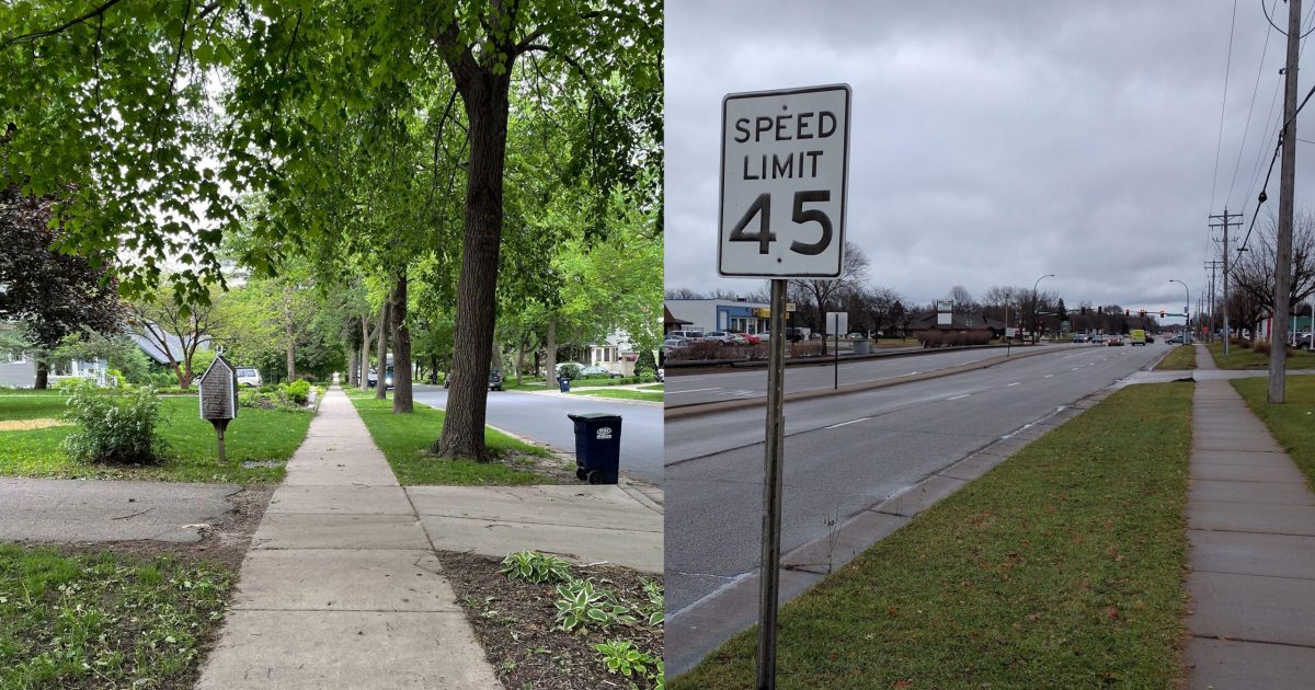
58th Street in Edina is ADA-compliant, and probably safe enough to cross with low volumes. But the experience is undignified, with little separation from car traffic, and no shade.
In the middle of the pyramid you have safety — both perceived and actual. It is possible to create a facility that is compliant but does not seem very safe. Picture sparkling new curb ramps to cross a 45-mph surface street with no marked crosswalk. In other cases, facilities are well-designed and safe, but may still not be dignified.
An example of this is in my own backyard, on Hennepin County’s Nicollet Avenue. A very-welcome project last year installed new crosswalks to popular Augsburg Park. These have durable crosswalk markings, excellent signage and refuge medians. But crossing still feels like a negotiation with drivers. And the overall sidewalk experience on the 1950s street is still lacking, with sidewalks at the back-of-curb and little to no shade.
Nicollet Avenue and 71st Street in Richfield
Dignity: Making Walking Feel Right
Finally, we have dignity. To determine whether a facility is dignified, I propose a simple test:
If you were driving past and saw a friend walking or rolling there, what would your first thought be:
1. “Oh, no, Henry’s car must have broken down! I better offer him a ride.”
2. “Oh, looks like Henry’s out for a walk! I should text him later.”
This is a surprisingly good test. Picture seeing your friend on a leafy sidewalk versus walking along a 45 mph suburban arterial. What would you think intuitively?
But to get more specific, these are the key factors in making a pedestrian experience dignified:
Shade and light
Convenience
Enclosure and proportions
Engagement
Shade and Light
St. Olaf Avenue in Northfield has a dignified amount of shade — not tunnel-like, but keeping the sidewalk cool and protected from the sun.
A dignified facility needs consistent shade during hot summer months. At night, shadows should be minimal and the route should be clear. Especially when a tree canopy is present, this is best achieved with more individual fixtures installed lower to the ground and at a lower light output. However, a fairly consistent light level can be achieved even with basic cobraheads, as long as there are enough to light the corridor fully.
The flowers are beautiful, but a dark street at night is less dignified than a well-lit one. Left is 70th Street near Garfield Avenue; right is Lyndale and 75th.
Convenience
Routes should be intuitive, easy, and not feel tedious to navigate. Having to make sharp, 90° turns or go out of your way feel awkward and make you feel like your time and effort is wasted — even if the detour is relatively minor.
Inconvenient pedestrian routing at York and 66thA winding path around a bus stop pull-out on 82nd Street
Enclosure and Proportions
Compare these two streets in Hopkins: Shady Oak Road, which is wide open with sense of enclosure, and Eighth Avenue, which is better-proportioned with a clear street wall.
It’s a very uncomfortable experience to walk along a wide-open corridor with no walls or edge definition — and it’s a common experience along suburban arterials, where you may have a wide road on one side and a wide-open parking lot on the other. You feel exposed and vulnerable. At the same time, overgrown sidewalks or ones that encroach on pedestrian space can feel claustrophobic and inconvenient. The right balance is needed.
Engagement
This sidewalk in Brooklyn Park has only the frontage of dilapidated privacy fences.
Finally, engaging frontage is always more appealing than blank frontage. The extreme of this principle is obvious: Walking down a traditional main street is more pleasurable than walking through an industrial park. But even where land uses are similar, engagement of frontage can vary a lot: picture the difference between walking past front doors of houses in a traditional neighborhood, and walking past privacy fences and back yards in cul-de-sac suburban neighborhoods. The traditional neighborhood is more interesting and engaging to walk through.
When I was visiting downtown Northfield, I noted a new building along Water Street (MN-3), which had similar materials to the older downtown buildings on Division: windows, brick, [cultured] stone base. Yet the back was turned to the street, and the experience walking past was undignified.
Consider the visual interest of these buildings in downtown Northfield. On the left, walking past tinted windows and blank walls on a new building along a concurrent section of Water St and Highway 3 on the west side of downtown. On the right, Division Street’s engaging storefronts.
A Pedestrian Cannot Live on Compliance Alone
Creating compliant sidewalks and trails is a high priority for agencies seeking to avoid litigation and serve pedestrians on the most basic level. Although that has some benefits, it isn’t enough. Whether actively undermining walkability (like removing crosswalks to achieve ADA compliance) to simply not doing enough (adding a new curb ramp to an otherwise wheelchair-hostile sidewalk), we need to go much further.
To make walking and rolling a desirable, everyday activity, we need facilities that are compliant, safe and dignified. We have many examples in our communities of great pedestrian ways — but we have a long way to go to make it universal, and truly move the needle toward walking.
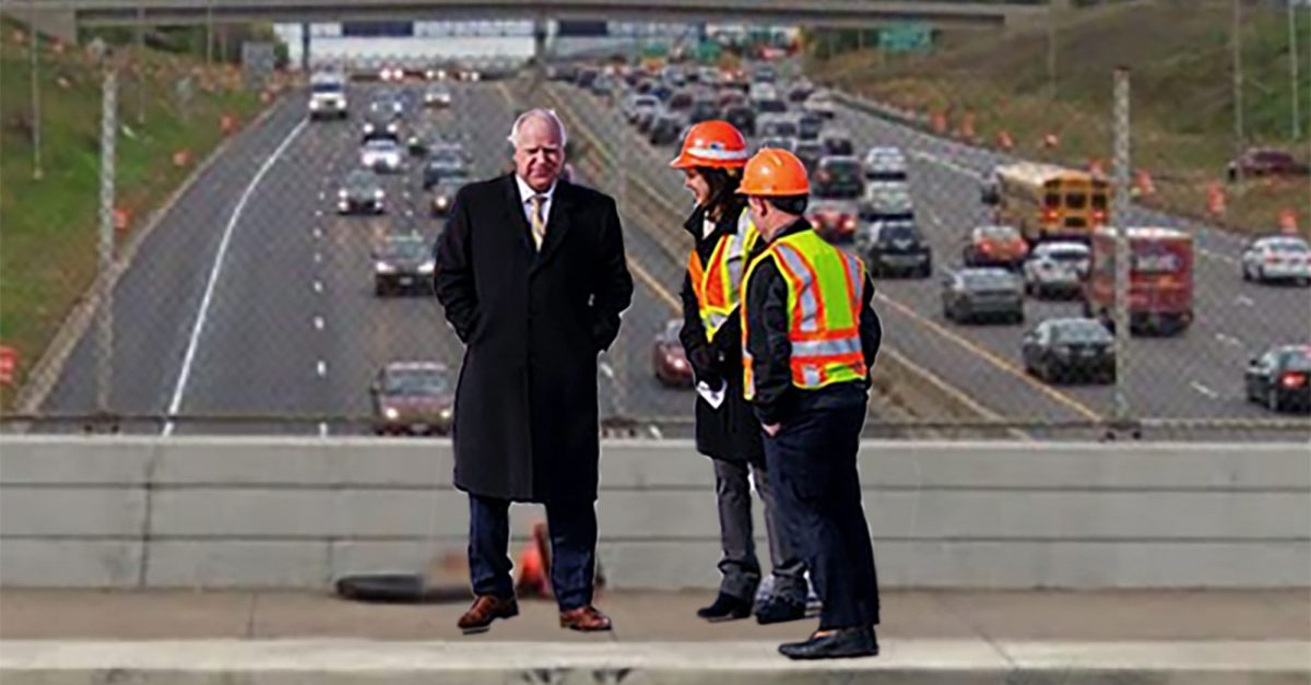
St. Paul, Minn — The Minnesota Department of Transportation (MnDOT) announced today the results of the Rethinking I-94 process — a comprehensive evaluation of the needs and opportunities of the Interstate 94 corridor in Minneapolis and St. Paul.
As a result of the study, MnDOT will be moving forward with an improvement project on the corridor — a strategic spot mobility improvement to 23 miles of freeway.
Gov. Tim Walz and MnDOT Nancy Daubenberger admire the scenic Interstate 94 corridor before today’s press conference.
“We know we can’t build our way out of congestion,” said Transportation Commissioner Nancy Daubenberger at today’s press conference. “Which is exactly why we’ve put the rethinking in Rethinking 94 — instead of trying to build our way out of congestion with more lanes, we’ll address congestion with comprehensive, multimodal solutions — such as building more lanes.”
MnDOT has long eschewed expansion, in an effort to lead the state in financially sustainable, environmentally sound infrastructure. Instead, the department has focused on spot mobility improvements, auxiliary lanes, safety and mobility improvements, and strategic improvements.
Graphic highlighting the improvements from the spot mobility improvement, as well as the properties identified for community reinvestment.
Locally preferred alternative presented, historical context noted
The locally preferred alternative for the I-94 corridor will not be an expansion, but merely a spot mobility improvement to the interstate, spanning from Brooklyn Center to Maplewood.
The plan will add two lanes in each direction for the 23 miles of interstate affected. “This will be a multimodal facility,” Daubenberger stated today. “One of those two new mobility-improved lanes will be a managed facility on the EZ Pass network. This means that for four hours a day, this lane will be reserved for transit, carpools, and EZ Pass users.”
“That’s right,” Daubenberger said with pause to let the significance set in among the crowd. “Twenty of the 168 hours of the week, one of those lanes will be dedicated to transit and carpooling. It is hard to imagine a greater investment in transportation alternatives.”
“It’s important to put this in context,” said Dave Johnson, MnDOT Metro Area Manager for Expansion Euphemism. “We know that this process is centered in an ugly legacy of building and widening highways through disadvantaged neighborhoods. We’ve learned our lessons, and now we approach this with an equity lens.”
“Today, we don’t bulldoze homes and businesses at the expense of neighborhoods. We invest in disadvantaged neighborhoods — by bulldozing homes and businesses.”
Johnson pointed to a recent small-scale example of this strategy: the interchange of I-94 and Dale Street, which included improvement of a small-business site into a vacant lot.
“Rethinking the use, function, and form of Interstate 94 was not within the scope of the ‘Rethinking I-94’ project,” Johnson clarified. “But our plan to add a strategic spot mobility improvement to 23 miles of the corridor shows that no idea is too original or ‘out of the box’ to be considered.”
Committed to green infrastructure
Although congestion relief alone is considered one of the greenest things an agency can do, MnDOT isn’t stopping there. “This will be green infrastructure, we’ll be planting over 500 trees in the corridor,” announced Governor Tim Walz, who also presented at today’s press conference.
When mature, 500 trees are expected to absorb 24,000 pounds of carbon dioxide each year. This is the equivalent of 1,200 gallons of gasoline — or about two drivers’ worth, each and every year.
“With 135,000 drivers on 94 each day, we’re proud to erase the emissions of nearly 0.0015% of those cars,” pronounced Walz proudly.
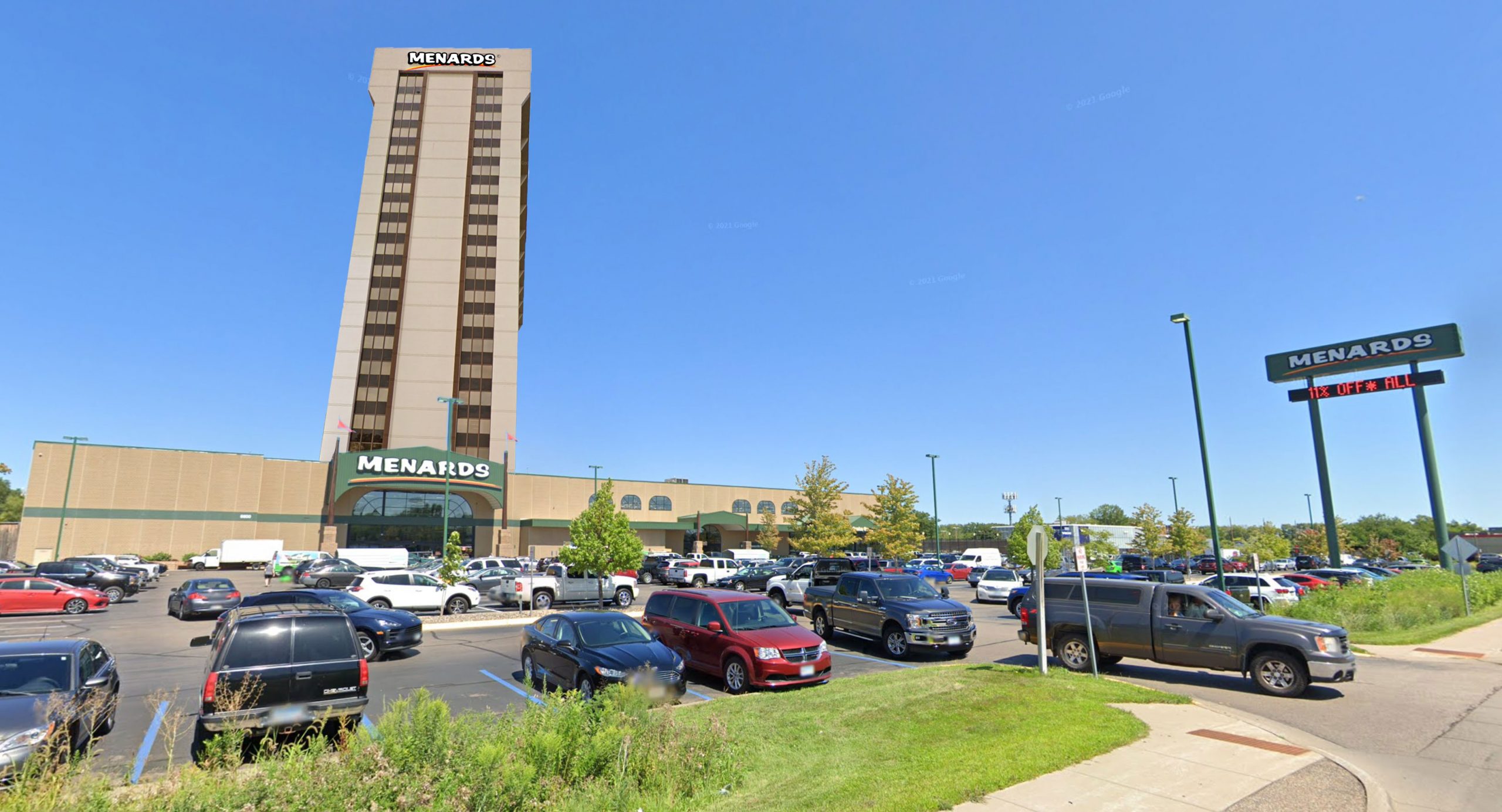
Golden Valley, Minn — following in the footsteps of other lifestyle brands, Wisconsin-based Menard, Inc. has announced ambitious plans to expand its home improvement stores into mixed-use lifestyle centers.
“Live. Work. Save Big Money.” is the co-living concept to integrate luxury apartments with everyday low prices on popular brands.
Following market trends
Although Menards Living promises to be the first home improvement-themed lifestyle apartments, it follows the lead of Lifetime Living, an apartment concept by Chanhassen-based Life Time Fitness.
Similar concepts have also been explored by workplace brand WeWork, and in the forms of national living concepts like City Club.
Common spaces will feature beloved Menards advertising on loop, and will be enhanced by Patriot Lighting
“Our customers are at least as enthusiastic about meeting their home improvement needs as Life Time customers are about going to the gym,” observed Henry Menard, director of Menards Living Division.
The Golden Valley Menards store will be the first site of a Menards Living tower, approximately 20 stories atop the retail store — promising views of 394, downtown Minneapolis, and the Menards parking lot. Apartments with a view of the lumber yard are expected to rent at a premium.
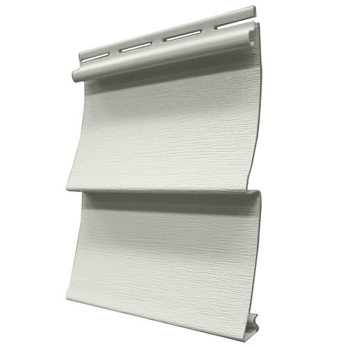
Only the highest-quality materials, such as Timbercrest vinyl siding, will be used on the tower
All exterior windows will be Mastercraft vinyl sliders, and the the tower will be clad in Timbercrest vinyl siding.
Amenities will include a thoughtfully branded rooftop deck, and TVs throughout common spaces playing Menards television commercials on loop.
A Menards jingle — “plumbing, electric, appliances too” — will play in all corridors and the parking garage at all times.
Future expansion plans
Menard reports that Menards Living won’t be stopping in Golden Valley, planning apartment towers of twenty or more stories at their at West St. Paul, Eden Prairie, Richfield, and Midway St. Paul locations next.
“No matter your preferred Menards, we want you to know: you never have to leave!” reassured Menard.
The rooftop pool deck will feature a subtle homage to Menards branding
Committed to affordability
To simplify the customer experience, rent will only be payable on BIG cards
Although the market price of apartments will start at $1600/mo, Menards has shown a commitment to affordable housing by offering tenants the opportunity to receive an 11% rebate each month.
They will need to submit rent receipts each month to a PO Box in Elk Mound, Wisc. with a hand-written rebate form. Rent rebates will be returned in 6 to 8 weeks, in the form of store credit.
All tenants will be able to pay rent monthly on their BIG Card. Tenants who lease in advance of the grand opening will receive a complimentary 35 oz jar of Cheese Balls.
Streets.mn reached out to Hobby Lobby, Cost Plus World Market, and Pamida regarding rumors of similar projects, but calls had not been returned at press time.
Last night, I attended a listening session for Lyndale Avenue in Minneapolis, focused on the serioussafetyissues between Lake Street and Franklin Avenue. The event was organized by the county commissioner for the area, Marion Greene. Dozens of neighbors spoke about their experiences walking, driving, and biking on Lyndale.
The neighbors covered a lot of issues: cars don’t stop, particularly at uncontrolled intersections (25th, 27th, 29th). Even at signals, driver behavior puts people walking at risk — one man was seriously injured after a crash at a light this past summer. Two others talked about the wearing emotional aspects of dealing with drivers harassing and threatening them for simply crossing the street.
After about an hour of testimony from residents, county engineer Carla Stueve gave some initial responses. Although she offered some welcome suggestions (bumpouts using plastic flex post delineators, turn restrictions), she immediately discounted the most significant tool that could improve Lyndale in the near term: a 4-to-3 conversion. This, she said, could only be done under a reconstruction but the county would “consider” this feedback at that time.
This is unacceptable.
Turning A Ship
People who attended the meeting were clearly hoping for something better than “considering” feedback at a distant, undefined date. Although Commissioner Marion Greene was clearly sympathetic to the need for action, she defended a slow process as necessary given the structure and practices of the county. This, she said, was like turning a ship — and must happen slowly.
Earlier in the same meeting, engineer Stueve noted that the street was constructed in 1954. From what I can tell, there have been no striping changes since that time. To me this demonstrated that the ship metaphor misses a key point: the nimbleness of the county isn’t the problem. The fact that the ship has been heading in the wrong direction on this street for 65 years is the problem. While the slow-turning ship may reflect past inaction on the street, it is not inevitable and should not confine a future vision for what this street can be.
The vast majority of these conversions were done with mill-and-overlay projects, where the top layer of road surface is replaced (much more quickly and cheaply than reconstructing). If the pavement were in good shape, they could simply grind out the old striping or seal coat over it and restripe without an overlay.
Restriping now is the right answer for Lyndale
Restriping Lyndale prior to a reconstruction would provide an immediate safety benefit, but it would also answer help key questions. We have seen this work in Richfield. In 2010, Hennepin County did an overlay and restripe of Portland Avenue — just five years before it would be fully reconstructed.
Portland Avenue in 2010, just after initial restripe
In addition to providing improvements sooner, it also helped guide the final redesign. For example: speeds were more consistent after the conversion, but still too fast, so they narrowed the lanes on the final restripe. Pedestrians still had difficulty crossing, so a marked crosswalk with a refuge island was included on every block. Shoulders provided a welcome option for bicycling on Portland, but families still didn’t feel safe biking with 35 mph traffic, so a mixed-use path was included in the reconstruct.
Portland Avenue after a reconstruction. Image: MnDOT and City of Richfield
Had we not done a “temporary” restripe, we would never have learned those things, and our reconstructed street would be less effective.
Lyndale would be the highest-volume 4-to-3 conversion Hennepin County has ever done. It’s no surprise that makes engineers more wary. But the precedent-setting nature of it is exactly why the County should act now, doing a 2020 test restripe and seeing actual results for people driving and walking alike.
Among those key questions that I think need to be answered are:
How does traffic respond to reduced capacity? Does some traffic shift to other streets?
How do signals perform in real-life conditions?
How are bus speeds impacted?
Are there any new specific safety issues created (e.g., passing on shoulder, aggressive turns off side streets)
I am not certain that a 3-lane layout will work for Lyndale. However, there a lot of variables to human behavior and I think these questions can best be answered in a real-life test of a 3-lane roadway. This would mirror Ramsey County’s highly successful effort on Maryland Avenue.
Restripe Lyndale as soon as the pavement is above freezing. Collect data throughout the summer, and decide whether to put it back (and prioritize reconstruction) or leave it in fall 2020. The time is now.
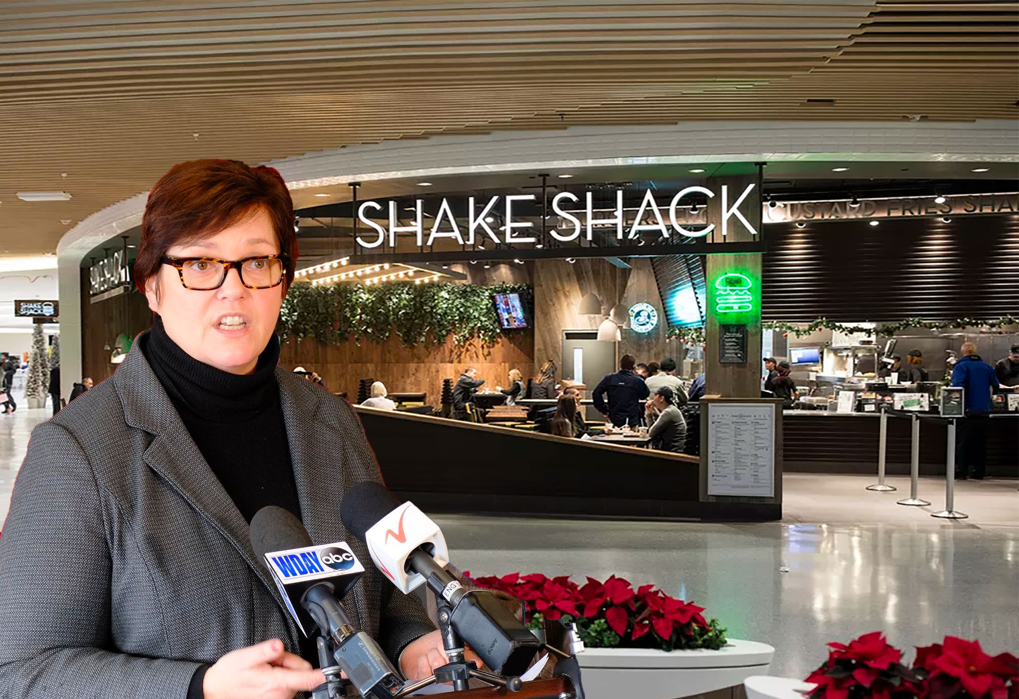
April 1, Bloomington — The Minnesota Department of Transportation (MnDOT) has announced an exciting new effort in its campaign to fight the dangerous epidemic of distracted walking, by targeting one of the metro area’s most dangerous areas for distracted pedestrians: the Mall of America.
“Distracted driving claims thousands of lives each year,” noted MnDOT Commissioner Margaret Anderson Kelliher at a press conference in front of the third floor Shake Shack. “Exactly why it’s time to do something about the truly dangerous activity of distracted walking.”
“Mall safety is a two-way street,” added the commissioner.
Commissioner Margaret Anderson Kelliher announced the campaign in front of Shake Shack. The photographer was required to pull over prior to taking the photo for safety.
Carnage from distracted walking
Commissioner Anderson Kelliher sat down with Streets.mn to give the inside scoop on the problem. As MnDOT’s Share the Road website noted, “Pedestrians and motorists are equally responsible for pedestrian safety. Motorist behaviors cause about half of all pedestrian-vehicle crashes and pedestrian behaviors cause the other half.”
Commissioner Anderson Kelliher further explained: “Since pedestrians are responsible for half of all crashes, we expect that half of those crashes still occur in an environment completely free of cars, such as inside the Mall of America. Halving fatalities sounds like a big improvement, but the extreme congestion at the Mall of America makes it one of the deadliest pedestrian environments in Minnesota.”
Mall-goers frequently are glued to their phones, causing hundreds of deadly collisions between pedestrians each year. Property damage has also occurred at the hands of 3 mph bipeds, including hundreds of upturned mall carts each year.
New campaign to promote awareness
New signs encourage safety at the Mall north entrance
A large banner will be installed over the new north entrance to the Mall. To encourage safety, patrons are encouraged to read the banner while driving, not walking.
Inside the mall, a new banner will remind pedestrians that “Mall safety is a two-way street.” Volunteers will be handing out tips to visitors. A safe reading area will be provided for pedestrians to pull over and absorb the information prior to beginning their shopping.
The following information will be distributed to each pedestrian entering the mall:
Look before you cross store entrances
Most crashes occur at intersections of two pedestrians.
Stop and make eye contact with all pedestrians who might be in your path.
Look at ALL lanes that enter and exit the store before crossing.
Make yourself visible
Stand clear of plants, benches and other objects before attempting to cross a store entrance.
Cross only near well-lit doors.
Wear bright-colored clothing.
Mount a safety flag on a wheelchair, motorized cart or stroller.
Avoid dangerous and distracted behaviors
Cross store entrances only at designated points.
Remove headphones before each entrance, and stay off mobile phones.
Don’t rely on signals. Remember, even if you have the right-of-way, you probably shouldn’t expect to have the right-of-way.
If intoxicated, don’t walk without assistance.
Bloomington partnering to provide engineering improvements to the Mall
The City of Bloomington is also committed to engineering changes to improve safety of pedestrians inside the mall. “With enough money, we can make the inside of the Mall of America as safe and enjoyable for pedestrians as the rest of the City of Bloomington,” said Julie Long, Bloomington’s city engineer, noting that the following images from the City’s Alternative Transportation Plan would guide the city’s approach to making a vibrant and safe mall walking environment:
To help facilitate the financing of these improvements, the city will be waiving the Mall of America’s property taxes for an additional 25 years.
Last spring, at a voter forum for Richfield’s west-side City Council seat, there were a number of questions about the mid-century commercial development that lines Penn Avenue between the Crosstown and 68th Street. Voters and candidates spoke of “tired” buildings, non-conforming sites, and inadequate parking. These questions about Penn Avenue seem to come up in every election cycle, and our elected officials are often put on the defense of why there continue to be vacant storefronts, and almost no major redevelopment.
The longer I’ve lived in Richfield, and the more deeply I’ve become involved in conversations around development, the more I have come to realize something: yes, Penn Avenue has all of those “problems.” But many aren’t problems at all. They’re what makes this corridor the best hub of small business in Richfield. And there are better ways to make this area even better.
Small businesses along Penn Avenue
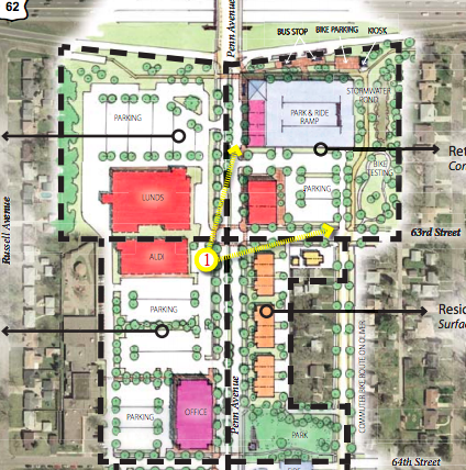
Meet Penn Central
Immediately south of Crosstown Highway, Penn Avenue is true mix of styles and types of businesses. The massive parking lot of the Lunds store is the first thing you’ll see on the west, while the east side is littered with independent small businesses, ranging from Woof Central doggy daycare to Johnston’s Vac and Sew to one of only two classic barber shops in the city. Around the corner at 66th, you’ll find Aida, one of my favorite restaurants in the city.
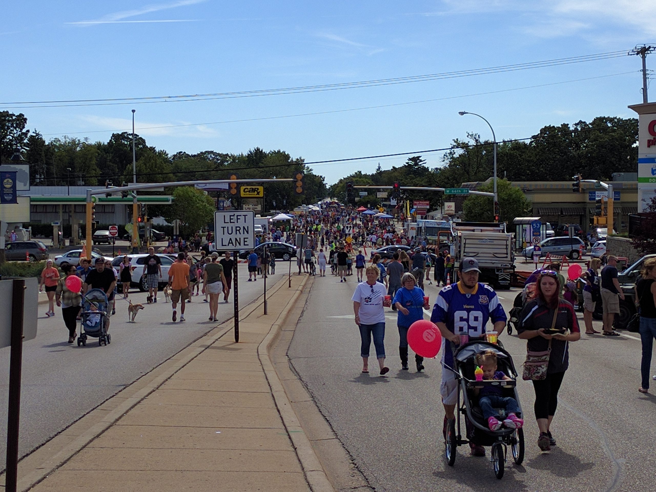
The distinctive small business district has an informal business association, and has branded their neighborhood as Penn Central. This organization, together with the City, hosts Richfield’s annual Open Streets festival, PennFest.
Open Streets at PennFest
The fact that small business is concentrated on Penn is no accident: these “tired” buildings on small lots are affordable and accessible to small businesses. As a planning commissioner, I have often heard residents share concerns that new development only brings more chains to the community. This, also, is no accident: chains can afford higher rent, and have more specific requirements for their building that are easier to do with new construction.
Cities do not have the right to control if a chain or small business is allowed to occupy a building — but we do make a choice in terms of what environment we want to create. Replacing affordable older buildings with brand-new buildings will have the effect of displacing small business and attracting more national chains. That may be inevitable, but it does not have to be a process we help accelerate.
The Penn Avenue Guidelines are the wrong solution to a problem that doesn’t exist
In 2008, in response to ongoing desires to improve the Penn corridor, the City contracted with an outside consultant to create a new master plan for the area. This process was valuable, and has given us a rigorous, high-quality zoning code for the area, that includes important features to improve the pedestrian environment, ensure high-quality development, and to limit uses that detract from the neighboring properties, like auto sales and drive-thrus.
However, the big picture proposed by the plan is disturbing. In a hypothetical redevelopment scenario, the plan envisions every single unit of small, affordable space for small business being eliminated — replaced by larger, mixed-use buildings. Even worse: the plan envisions every single piece of existing naturally occurring affordable housing being replaced.
This is not a good end-goal to have — if we were “successful”, we would eliminate important parts of our local economy, and the exciting, interesting businesses that help make Richfield a great place to live.
With no problem to solve, we don’t need to be desperate
The first project proposed after the Penn Avenue plan was a CVS Pharmacy. This project went against many of the principles of the plan: it was large, single-use retail. Facing the sidewalk, it didn’t offer the customer entrances, display windows, and awnings envisioned — instead it had a large, blank retaining wall, which allowed the parking lot to loom over Penn Avenue. But it was approved, feeling that demonstrating some sign of life would help inspire additional redevelopment.
Since that building was built six years ago, there has been no new construction on the corridor, although most existing businesses continue to thrive. Now, the City is considering an application for the first new development proposed in years: a fast food restaurant. Like CVS, this would be another single-use chain, this time with half the required density, and with a drive-thru speaker that is half the required distance to housing.
Proposed fast-food restaurant space
The Planning Commission, on which I serve, voted against the variances that would allow this fast-food restaurant to build — although it remains to be seen if the City Council will accept or overrule that recommendation. The problems with the development are significant, and it was clear to me as a planning commissioner that they did not meet the specific standards for the variances they were seeking.
In the bigger picture, developments like this fast food restaurant offer little to the community. They are certainly not the high-intensity development that the Penn Avenue Guidelines envision. Occupying a tiny portion of the site, they do not offer much improvement to the tax base. They have significant externalities in terms of noise, air pollution, and traffic. And they replace more-affordable commercial property with less-affordable new development.
How to fix Penn Avenue? Fix Penn Avenue.
Although it offers a lot to the community, there are admittedly problems on Penn: some spaces remain persistently vacant, and the cosmetic appearance of the corridor is poor. If we want to improve the appearance of the corridor, let’s start with something that doesn’t have to cost businesses a dime, and something that we can do right away: rebuild Penn Avenue.
The sidewalk by the Fireside Foundry parking lot is simply an unstriped portion of the lot, made inaccessible by the driveway apron. Image: Google Street View.
The four-lane death road, owned by Hennepin County, is a grim relic of yesterday’s engineering. Sidewalks are completely inaccessible. Speeding is common. On-street parking that could serve businesses exists for only a single block. Crossing from one side of the street to another — a key component of a walkable business district — is all but impossible.
Let’s not eliminate our small business corridor. Let’s help it thrive, by giving businesses an attractive home, and giving their customers and our residents a safe place to walk, shop, and live.
streets.mn-exclusive aerial rendering of improved Ford site
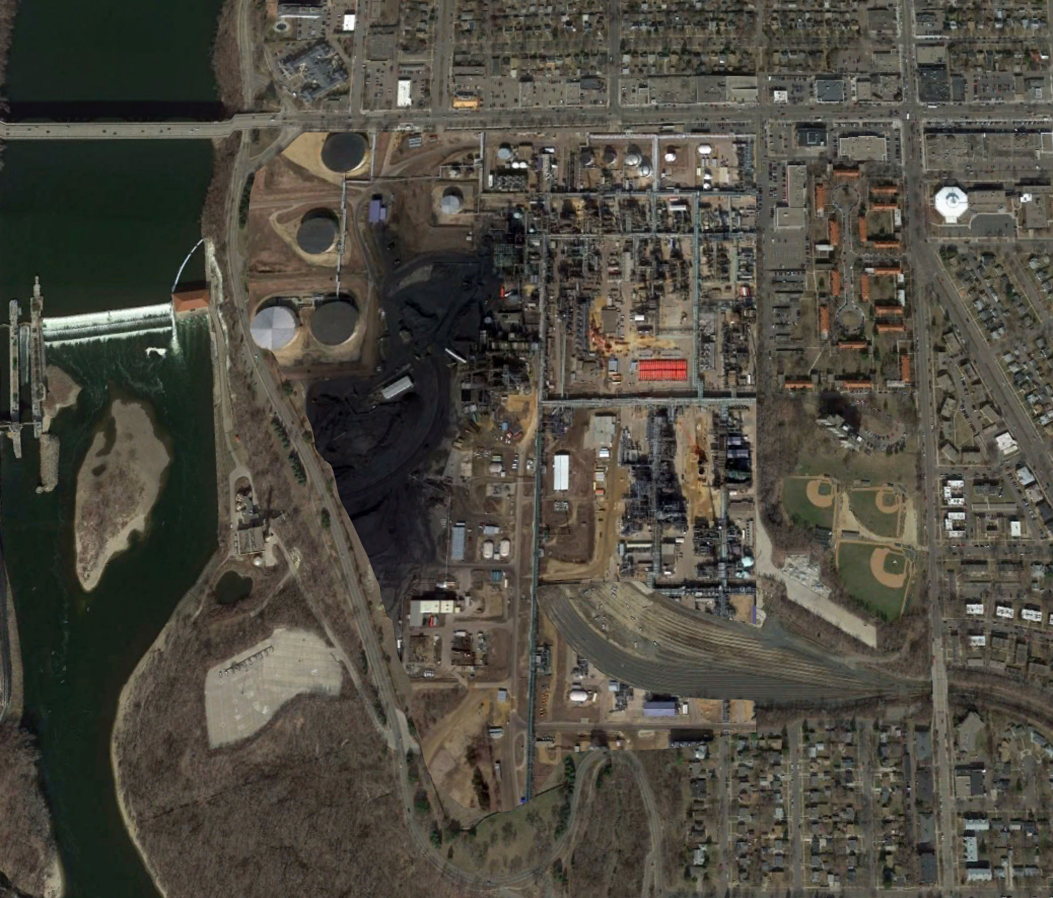
St. Paul, Minnesota — residents of the Highland Park neighborhood have been struggling for months against an outrageous proposal to redevelop the Ford Site with business, homes, and public green space. Today, Neighbors for a Livable St. Paul announced the results of their successful campaign to preserve neighborhood character. Instead of unsightly urban apartment homes, the industrial legacy of the site will be preserved, through the construction of a new oil refinery.
“We have long treasured the pristine open space afforded to us by the Ford plant,” neighborhood activist Gertrude Lowerthan wrote in a letter to the Highland Villager. “Other than the smoke stacks, the new Highland Park Refinery will afford neighbors uninterrupted views of the Mississippi.”
Site Plan Changes
The original site plan called for an unattractive mix of various forms of “pack and stack” housing, and an almost dizzying array of streets matching the surrounding grid. The new site plan is considered “context-sensitive” by the neighborhood, by preserving the existing vibrant mix of uses provided by the Ford plant.
The original designations proposed by planners would bring business, residents, and attractive public spaces to the neighborhood, ruining the surrounding character.
The revised site plan will preserve the neighborhood character of the historic Ford Plant.
“Now that’s a refined site plan,” grinned Scott Bensin, president of the Highland District Council. “Maybe in some places, they might like to have families, kids, dogs, and green space next door. But our residents are holding firm in Highland Park against this Minneapolification of St. Paul. Why have people living across the street when you can have something less impactful — like heavy industrial?”
Keeping the River Pristine
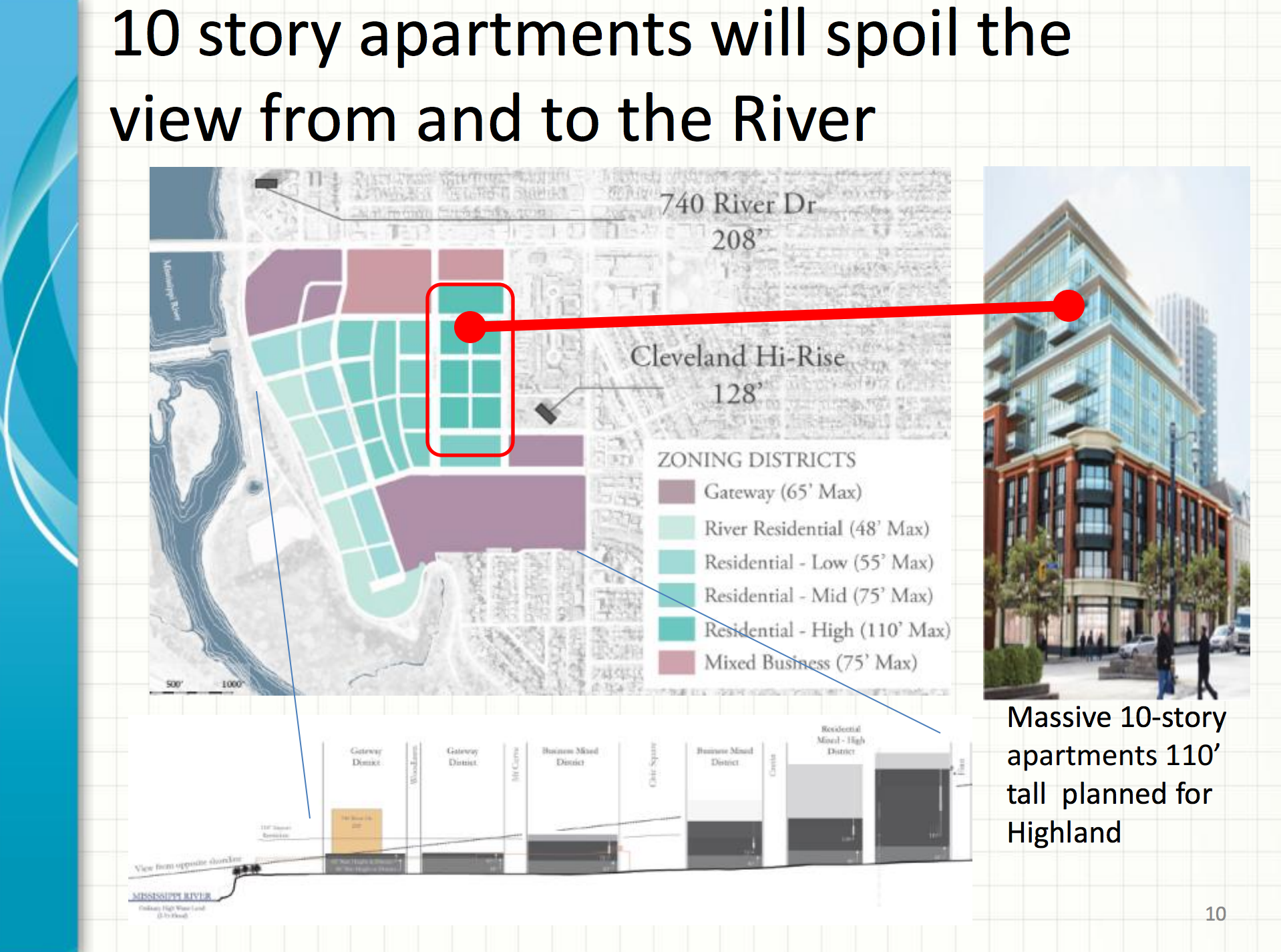
One particular sticking point for the previous plans for the Ford site was the changes to the feel for Mississippi River Blvd. Planners proposed buildings up to 48′ high front Mississippi River Blvd. Neighbors for a Livable St. Paul noted that this would ruin views from the parkway, spoiling the natural surrounding.
The new refinery will rebuild the historic Ford concrete wall, preserving the decades-old view from River Blvd for years to come.
The scenic views of the site from Mississippi River Blvd, pictured here from 2011, will be left unscathed by the new refinery. Image: Google Maps
I spend a lot of time thinking about the 494 strip. I work out of a coworking space near 494 and 100, and live less than a mile north of the highway in Richfield. As a Richfield planning commissioner, I have seen manyprojects revolve around 494 visibility and access. On a broader level, Richfield has ambitious goals for high-intensity development along the strip.
Richfield isn’t alone. The 494/5 commons between the airport and Eden Prairie has one of the highest concentrations of destinations in the region, having been classified as an “edge city” in the planning book by the same name. The Southdale District is a particularly large concentration of development just north of 494. And all three of Bloomington’s “development districts” center around 494.
Congestion
If you talk to the average car commuter about this section of I-494, the first thing they’re likely to talk about isn’t the concentration of destinations. They’re likely to talk about the congestion. The area immediately around 35W experiences over six hours of congestion per day. The only solution to this problem? More lanes, and better interchanges.
Building more lanes will kick the can down the road for another few years, but it doesn’t address the fundamental problem: each city wants to build high-intensity, auto-oriented destinations along a highway that will only get more congested.
After decades of drawing attention to the matter, we have made no serious progress on expanding 494 or the the 35W interchange. If we’re lucky, we’ll get $75 million for a partial improvement to westbound 494. But what then? 494 will hardly become uncongested — even on day 1 of an improved interchange. And if the cities along the strip achieve their goals, much more traffic will continue to pour onto the freeway.
Pentagon Park
To get a sense of just how intensely new development wants to add to traffic congestion on 494, check out this staff report on Edina’s Pentagon Park, which includes a consultant’s report describing the local street improvements needed for the development to move forward. Among the changes needed:
Additional southbound lane on France Ave
Double-left turn lanes at nearly every signal within a mile’s drive of the development
Upgrading the existing 5-lane 77th Street Bridge over TH 100 to a minimum of 8 lanes.
Despite the detailed, comprehensive vision on the auto improvements needed, this is the entirety of what they describe for bicycles, pedestrians, and transit:
This lacks the rigor of the auto analysis, and fundamentally assumes one thing: nobody walks.
They key problem with this section of France Avenue? Not enough lanes. Image: Google Maps.
Transit viability
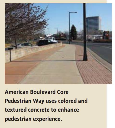
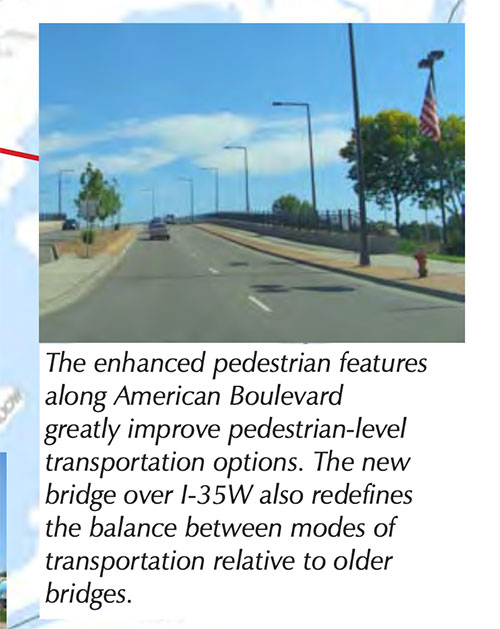
For an auto-oriented strip, 494 has reasonably good transit options. In addition to express routes to downtown and the future Orange Line near 35W, 77th/76th St and American Blvd both have all-day local bus options. But the streets are not set up for the walking and biking needed to actually use transit. And development often turns a blind eye to people walking or arriving from transit. As a result, even achieving the live-work mixes we hope to add in the strip, few would choose to use transit if they have the option to drive their own car.
Even the new Lyndale Ave interchange provides a noisy, stressful pedestrian experience.
Including walking, biking, and transit
To grow the 494 strip to cities’ goals, we need to rethink our approach to development and the streets in the corridor. I fully expect that developers’ main interest in 494 will be driven by its high auto traffic. But cities need to channel that interest into something that works for a multi-modal future. Cars are a big part of that future — but they can’t sustain 494 alone.


 After about an hour of testimony from residents, county engineer Carla Stueve gave some initial responses. Although she offered some welcome suggestions (bumpouts using plastic flex post delineators, turn restrictions), she immediately discounted the most significant tool that could improve Lyndale in the near term: a 4-to-3 conversion. This, she said, could only be done under a reconstruction but the county would “consider” this feedback at that time.


